| Collection |
General Collection |
| Date |
1882 |
| Abstract |
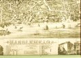
Map/drawing of Marblehead as far as Sewell, Elm & Pond streets to the North and Waldron and School streets to the West and the harbor to the South. The buildings are drawn in together with rail road tracks and boats in the harbor. The major buildings and places numbered and listed at the bottom. Also at the bottom are 4 additional drawings, Devereux map, Abbot Hall, Marblehead Academy, and Peaches Point map. Printed in brown ink.
It is the same as #2001-065-0192 except it has been cut to fit in the frame. |
| Home Location |
Hanging on wall |
| Object ID |
2000-008-008 |
| Object Name |
Map |
| People |
Graves, M. H
Bailey, G. H. |
| Search Terms |
Marblehead Maps |
| Title |
Marblehead |
|