|
Record 2647/5355 |
|
|
|
Description
|
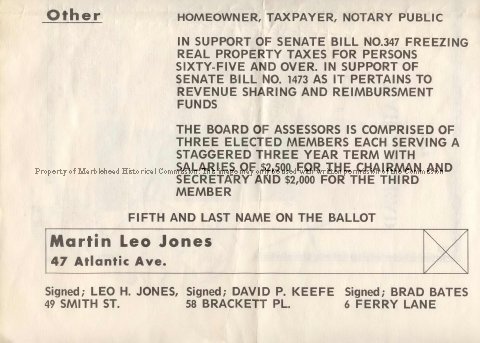
| Single sheet with a map of Marblehead which included the streets from Grace Oliver's Beach to the harbor to Chestnut Street , Village Street as far as the R.R. bridge, up to the Robinson Farm Green Street to the Powder House, Pond Street, Redd's Pond and back to Grace Oliver's Beach. It shows the streets, buildings and the owners. It does not include the Neck, Devereux, Clifton, West Shore, Peaches Point or Naugus Head. On the back is a political poster for Martin Leo Jones running for the position of Assessor. It gives his address as 47 Atlantic Ave. and is endorsed by Leo H. Jones of 49 Smith Street, David P. Keefe of 58 Brackett Pl. and Brad Bates of 6 Ferry Lane. |
Marblehead 1879
-Archives Catalog
-Copyright Marblehead Historical Commission
COPYRIGHT INFORMATION ~ Contact the Marblehead Historical Commission for rights to use this image.
| Jones Adv. 2 |
COPYRIGHT INFORMATION ~ Contact the Marblehead Historical Commission for rights to use this image.