|
Record 2900/5355 |
|
Description
|
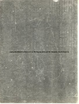
| A white on black photo copy of a hand drawn map of Marblehead dated 1795. Also labeled and dated Old Marblehead Map 1-16-1943 and 11-12-13 Salem line. It is an outline of the town and neck with a few streets indicated and 23 spots numbered to 23. Not all the numbers are used. It is cut off on the left edge and some of the numbers are guessed at. 6. Fort 7. or 9. New Wharf 8. Wharf at Nicks Ave. 9. Red's (sic) Pond 10. Devereux Pond 11. Monument on the Beach 12.Forrest River 13. or 14. **rdns Mill 15. Gerry Island 16. ***ne's Island 17. Newtown Bridge 18. Bridge on Bubier Plan 19. Nuits (Hewitt's) Mill 20. Great Neck 21. Neck Pond 22. Guide Post 23. Nogg's Head |
Map
-Archives Catalog
-Copyright Marblehead Historical Commission
COPYRIGHT INFORMATION ~ Contact the Marblehead Historical Commission for rights to use this image.
| 1795 Marblehead Map |
COPYRIGHT INFORMATION ~ Contact the Marblehead Historical Commission for rights to use this image.