Salem Harbor Massachusetts
Archives Catalog
|
|
|
| Collection |
William Hammond Collection |
| Abstract |
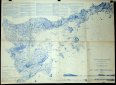
A chart of Salem Bay including Marblehead, Marblehead Neck, Marblehead Harbor, Salem, Salem Harbor and the North coast of Salem Bay as far to the NE as Kettle Cove. It was printed in blue ink and published in 1855 and a new edition in 1869. In the upper left corner there are extensive sailing directions to enter Salem Harbor.
In the lower right corner there are Views of entrance to Salem Harbor by Cat Island Channel when Halfway Rock bears N.W 3/4 N (by Compass.) The other view is entrance to Salem Harbor by Main Ship Channel, Baker's Island Light W 3/4 N (by Compass.)
|
| Home Location |
Z Box 18X13 Charlie Shelf#4 |
| Object ID |
2005-018-00141 |
| Object Name |
Map |
| Search Terms |
Salem
Salem Harbor |
| Title |
Salem Harbor Massachusetts |
|
|
COPYRIGHT INFORMATION ~ Contact the Marblehead Historical Commission for rights to use this image.
|
|
|
Rev. 2.0 2/2013 Contact the Historical Commission at 781-639-3425 or e-mail us (please include the "Object ID" number, not the Record Number)
historic@marblehead.org
Last modified on: February 22, 2013
|