|
|
| Collection |
General Collection |
| Date |
September 6. 1959 |
| Abstract |
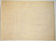
A map showing the plan for dividing up the lots on Clifton Heights Lane and Joel Road, both off of Atlantic Ave. Also a profile of a proposed sewer and deain easement for Joel Road. |
| Home Location |
GG Pink Room Flat File Drawer#2 |
| Object ID |
2007-201-02129 |
| Object Name |
Map |
| People |
Parsons, John W. |
| Search Terms |
Marblehead maps
Atlantic Ave. |
|
|
COPYRIGHT INFORMATION ~ Contact the Marblehead Historical Commission for rights to use this image.
|
|
|
Rev. 2.0 2/2013 Contact the Historical Commission at 781-639-3425 or e-mail us (please include the "Object ID" number, not the Record Number)
historic@marblehead.org
Last modified on: February 22, 2013
|