Marblehead 1872
Archives Catalog
|
|
|
| Collection |
Marblehead Maritime Museum, Sponsored by Dr. Raymond F. Cole, Jr. |
| Date |
1872 |
| Abstract |
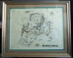
Framed under glass map of Marblehead dated 1872.
This map features the following:
1. The names of owners of houses not in the main residential area from the Shipyards to Fort Sewall
2. The Marblehead Branch R.R. but not the railroad from Swampscott.
3. Atlantic Avenue from The Swampscott line to Ocean avenue.
4. Four Indian cemetery
A. opposite Great Head (Now known as Castle Rock)
B. Just south of Waterside Cemetery
C. At Wyman's Cove.
D. About where Treat Road is now.
5. Most of the Neck is labeled Camp Lowell Village. The area north of Castle Rock is labeled Nashua Village.
6. There is a Ice Ho (ice house) on West Street.
7. Children's Island is labeled Lowell or Cat Is. |
| Home Location |
Uniform Cabinet Shelf #3 |
| Object ID |
2007-300-03312 |
| Object Name |
Map |
| Search Terms |
Marblehead Map 1872 |
| Title |
Marblehead 1872 |
|
|
COPYRIGHT INFORMATION ~ Contact the Marblehead Historical Commission for rights to use this image.
|
|
|
Rev. 2.0 2/2013 Contact the Historical Commission at 781-639-3425 or e-mail us (please include the "Object ID" number, not the Record Number)
historic@marblehead.org
Last modified on: February 22, 2013
|