|
Record 3760/5355 |
|
|
|
Description
|
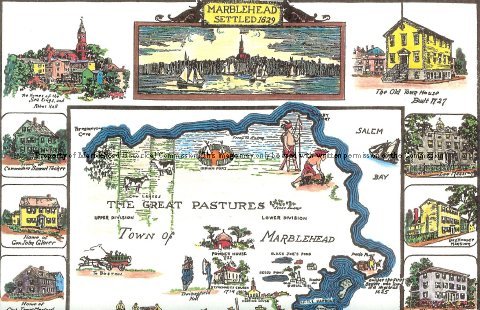
| Print of a hand-colored map of Marblehead originally made by C. H. Snow in 1929 and colored by Warren Perry in 2008. The map shows the outlines of Marblehead peninsula and the Neck, along with historical pieces of information. The map is surrounded by drawings of historical Marblehead buildings and the Hannah. |
C. H. Snow Marblehead Map
-Archives Catalog
-Copyright Marblehead Historical Commission
COPYRIGHT INFORMATION ~ Contact the Marblehead Historical Commission for rights to use this image.
| C. H. Snow Marblehead Map |
COPYRIGHT INFORMATION ~ Contact the Marblehead Historical Commission for rights to use this image.