Topic: Around town
Map year 1700
|
|
|
| Catalog date |
12/22/2003 |
| Category |
8: Communication Artifact |
| Classification |
Maps |
| Collection |
Bowd Osborne color slides |
| Date of photo |
1700 |
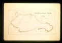
| Description |
Map of Marblehead Neck. Most of the land is labeled Common Land with a two small lots labled John Pedrick. There is one road across from near the causway to the ocean side of the Neck.
.
|
| Home Location |
BM Slide Carousel Conf. Rm. Wood Shelf#3 |
| Object ID |
1961-001-00472 |
| Object Name |
Transparency, Slide |
| People |
Pedrick, John |
| Place |
Marblehead |
| Search Terms |
Marblehead Maps |
| Sub-category |
Documentary Artifact |
| Subjects |
Maps |
| Title |
Map year 1700 |
| Year Range from |
1700 |
|
|
COPYRIGHT INFORMATION ~ This image is the property of the Marblehead Historical Commission and may not be used in any form without prior permission. When using this image with permission, the credit information should be in the following format: Image courtesy of the Marblehead Historical Commission, Marblehead, MA.
|
|
|
Rev. 1.0a 1/2009 Contact the Historical Commission at 781-639-3425 or e-mail us (please include the "Object ID" number) at: butlerw@marblehead.org
Last modified on: January 05, 2009
|