|
Record 163/1387 |
|
Description
|
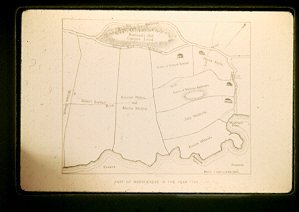
| Map of Marblehead. The part along the harbor from Skinners head to Cow Fort inland as far as Rowland Hill. . |
Map year 1700
-Topic: Around town
-This image is the property of the Marblehead Historical Commission
COPYRIGHT INFORMATION ~ This image is the property of the Marblehead Historical Commission and may not be used in any form without prior permission. When using this image with permission, the credit information should be in the following format: Image courtesy of the Marblehead Historical Commission, Marblehead, MA.
| Map of Marblehead |
COPYRIGHT INFORMATION ~ This image is the property of the Marblehead Historical Commission and may not be used in any form without prior permission. When using this image with permission, the credit information should be in the following format: Image courtesy of the Marblehead Historical Commission, Marblehead, MA.