|
Record 181/1387 |
|
Description
|
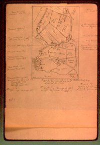
| Hand drawn map of Marblehead with several notes in the wide margins. The map shows the area on the harbor from Codner's Cove (Stacey Landing) to Boston Yacht Club and inland as far as Elm Street . |
Transparency, Slide
-Topic: Around town
-This image is the property of the Marblehead Historical Commission
COPYRIGHT INFORMATION ~ This image is the property of the Marblehead Historical Commission and may not be used in any form without prior permission. When using this image with permission, the credit information should be in the following format: Image courtesy of the Marblehead Historical Commission, Marblehead, MA.
| Map of Marblehead with additio |
COPYRIGHT INFORMATION ~ This image is the property of the Marblehead Historical Commission and may not be used in any form without prior permission. When using this image with permission, the credit information should be in the following format: Image courtesy of the Marblehead Historical Commission, Marblehead, MA.