|
Record 200/1387 |
|
Description
|
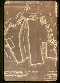
| A plot plan of the area around the junction of Water and Front Streets. It includes Nick's Cove, the lot where the BYC now stands and the South edge of Crocker Park. |
Transparency, Slide
-Topic: Around town
-This image is the property of the Marblehead Historical Commission
COPYRIGHT INFORMATION ~ This image is the property of the Marblehead Historical Commission and may not be used in any form without prior permission. When using this image with permission, the credit information should be in the following format: Image courtesy of the Marblehead Historical Commission, Marblehead, MA.
| Nick's Cove at end of Front St |
COPYRIGHT INFORMATION ~ This image is the property of the Marblehead Historical Commission and may not be used in any form without prior permission. When using this image with permission, the credit information should be in the following format: Image courtesy of the Marblehead Historical Commission, Marblehead, MA.