Topic: Around town
Marblehead
|
|
|
| Catalog date |
05/03/2004 |
| Category |
8: Communication Artifact |
| Classification |
Maps |
| Collection |
General Collection |
| Abstract |
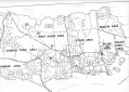
Part of a map of Marblehead which does not show the Neck. The town has been divided into 10 area with nine having labels. They are: Forest Area, Clifton Area, Chicken Farm Area, Dunbar Area, West Shore Area, Steer Area, Beacon Area, Peach (sic) Point Area and Black Joe Area. The tenth area has no label and is the oldest part of the town next to the harbor from the Old Burial Hill to the old high school on Pleasant Street. |
| Home Location |
N Box 18X13 Charlie Shelf#4 |
| Object ID |
2004-010-036 |
| Object Name |
Map |
| Search Terms |
Marblehead Maps |
| Sub-category |
Documentary Artifact |
| Subjects |
Maps |
| Title |
Marblehead |
|
|
COPYRIGHT INFORMATION ~ This image is the property of the Marblehead Historical Commission and may not be used in any form without prior permission. When using this image with permission, the credit information should be in the following format: Image courtesy of the Marblehead Historical Commission, Marblehead, MA.
|
|
|
Rev. 1.0a 1/2009 Contact the Historical Commission at 781-639-3425 or e-mail us (please include the "Object ID" number) at: butlerw@marblehead.org
Last modified on: January 05, 2009
|