|
Record 608/1387 |
|
Description
|
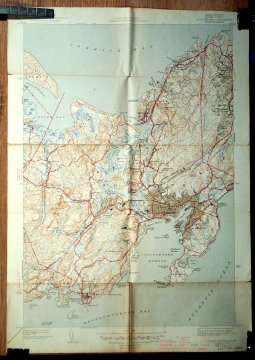
| One of a series of topographic maps of the United States prepared by the United States Geological Survey. "This work has been in progress since 1882 and the published maps cover more than 47 percent of the country, exclusive of outlying possessions" (as of November 1937.) The Corps of Engineers, U.S. Army was also involved in production of these maps. |
Gloucester, Mass.
-Topic: Around town
-This image is the property of the Marblehead Historical Commission
COPYRIGHT INFORMATION ~ This image is the property of the Marblehead Historical Commission and may not be used in any form without prior permission. When using this image with permission, the credit information should be in the following format: Image courtesy of the Marblehead Historical Commission, Marblehead, MA.
| Map of Gloucester MA |
COPYRIGHT INFORMATION ~ This image is the property of the Marblehead Historical Commission and may not be used in any form without prior permission. When using this image with permission, the credit information should be in the following format: Image courtesy of the Marblehead Historical Commission, Marblehead, MA.