|
Record 629/1387 |
|
Description
|
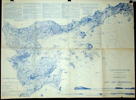
| A chart of Salem Bay including Marblehead, Marblehead Neck, Marblehead Harbor, Salem, Salem Harbor and the North coast of Salem Bay as far to the NE as Kettle Cove. It was printed in blue ink and published in 1855 and a new edition in 1869. In the upper left corner there are extensive sailing directions to enter Salem Harbor. In the lower right corner there are Views of entrance to Salem Harbor by Cat Island Channel when Halfway Rock bears N.W 3/4 N (by Compass.) The other view is entrance to Salem Harbor by Main Ship Channel, Baker's Island Light W 3/4 N (by Compass.) |
Salem Harbor Massachusetts
-Topic: Around town
-This image is the property of the Marblehead Historical Commission
COPYRIGHT INFORMATION ~ This image is the property of the Marblehead Historical Commission and may not be used in any form without prior permission. When using this image with permission, the credit information should be in the following format: Image courtesy of the Marblehead Historical Commission, Marblehead, MA.
| Salem Harbor |
COPYRIGHT INFORMATION ~ This image is the property of the Marblehead Historical Commission and may not be used in any form without prior permission. When using this image with permission, the credit information should be in the following format: Image courtesy of the Marblehead Historical Commission, Marblehead, MA.