Topic: Around town
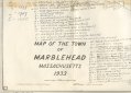
Map of the Town of Marblehead Massachusetts, 1933
|
|
|
| Catalog date |
08/16/2006 |
| Category |
8: Communication Artifact |
| Classification |
Maps
Streets & Byways
Waterfront |
| Collection |
General Collection |
| Date |
1933 revised. July 1942 |
| Abstract |
This map consist of parts of three town of Marblehead maps cut horizontality and taped together with masking tape. On the maps 29 places or areas are indicated with numbers which correspond with a list on the lower left of the map.
These palaces are:
1) Coy Pond [indicated at three places 1, 1A & 1B]
2) Hay Scales (2A) (New Location 1828)
3) Redstone Cove (3A) "Shipyard" Area
4) Cunny Lane (4A) Waldron's (4B) Gardeners Gut
5) Early Poorhouse (Workhouse Rocks) (5A) New Location
6) Old Meeting House (6A) New Meeting House
7) Newtown Bridge
8) Academy
9) Nicholson (Severitt) Hill
10) Bassett St. Blaney's Tan Yard
11) First (or Waldron's, or "Bushy" lane's) Cove
12) Washington Square ("Train'Foot") Hill
13) Prospect Alley (Other name Unprintable)
14) Tucker St. (Other name Unprintable)
15) Nick's (Nix) Cove (Dirtymoon Dock)
16) Lee Mansion (Marblehead Historical Society)
17) Codner's cove (Old State St . Wharf, now Philip T. Clark Landing)
18) "Back" (Now Elm) St. Site of Artillery Gun Shed
19) Doliber's Rocks
20) Methodist Rocks (Near old "Eel Pot" Church) Rockaway St. (Part nearest Pleasant St)
21) Rockaway St. - Frog Lane
22) State St.- King Street
22A) Glover Square (Around to Front from State)
23) Market (Town House) Square (Formerly State)
24) Green St. to Salem Ferry (Thos Dixie)
24A) "Tom Bowen's Church" at Ferry
24X) Beacon St. (Alternate Route to Ferry)
25) "Barnegat" 25X) Black Joe's Pond
26) Circle St. (Okum Bay) Lovis Cove
27) Homan's Cove (Beach)
28) Stacey St. (Chinatown)
29) Evans Rd (B&B Cornish's Path)
There are 5 routes out of town indicated by letters
A = 1687 (Humphrey Street)
B = (Unreadable) (Through Vinnin Square area)
C = 1666 (Across Forest River at bottom of Legg's Hill)
D = 1707 (Across Forest River at Led Mills)
E = 1640 ( Ferry to Salem at end of Green Street)
|
| Home Location |
FF Box 18X13 Charlie Shelf#5 |
| Object ID |
2006-054-00208 |
| Object Name |
Map |
| Search Terms |
Marblehead Maps |
| Sub-category |
Documentary Artifact |
| Subjects |
Maps
Streets
Waterfronts |
| Title |
Map of the Town of Marblehead Massachusetts, 1933 |
|
|
COPYRIGHT INFORMATION ~ This image is the property of the Marblehead Historical Commission and may not be used in any form without prior permission. When using this image with permission, the credit information should be in the following format: Image courtesy of the Marblehead Historical Commission, Marblehead, MA.
|
|
|
Rev. 1.0a 1/2009 Contact the Historical Commission at 781-639-3425 or e-mail us (please include the "Object ID" number) at: butlerw@marblehead.org
Last modified on: January 05, 2009
|