Topic: Around town
The North Shore
|
|
|
| Catalog date |
08/08/2008 |
| Catalog type |
History |
| Category |
8: Communication Artifact |
| Classification |
Maps |
| Collection |
Marblehead Maritime Museum, Sponsored by Dr. Raymond F. Cole, Jr. |
| Date |
1959 |
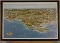
| Description |
Map/drawing of the North shore of Boston from Swampscott to Plum Island with Cape Ann in the center. It includes major roads and highways. |
| Dimensions |
H-11 W-16.5 inches |
| Home Location |
Maritime Room |
| Object ID |
2007-300-03211 |
| Object Name |
Map |
| Search Terms |
North Shore
Northshore |
| Sub-category |
Documentary Artifact |
| Subjects |
Maps |
| Title |
The North Shore |
|
|
COPYRIGHT INFORMATION ~ This image is the property of the Marblehead Historical Commission and may not be used in any form without prior permission. When using this image with permission, the credit information should be in the following format: Image courtesy of the Marblehead Historical Commission, Marblehead, MA.
|
|
|
Rev. 1.0a 1/2009 Contact the Historical Commission at 781-639-3425 or e-mail us (please include the "Object ID" number) at: butlerw@marblehead.org
Last modified on: January 05, 2009
|