|
Record 1276/1387 |
|
Description
|
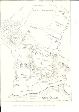
| A B&W photo copy of a portion of a Marblehead map in the year 1700. The map shows Gatchell's Hill, "The Highway" (Washington St.), roads that are presently South and Midle Streets, the Commons (where Abbot Hall is today) and a portion of the harbor, including Nick's Cove. Land parcels are shown along with the owners' names. |
Marblehead Map segment
-Topic: Around town
-This image is the property of the Marblehead Historical Commission
COPYRIGHT INFORMATION ~ This image is the property of the Marblehead Historical Commission and may not be used in any form without prior permission. When using this image with permission, the credit information should be in the following format: Image courtesy of the Marblehead Historical Commission, Marblehead, MA.
| Marblehead Map segment |
COPYRIGHT INFORMATION ~ This image is the property of the Marblehead Historical Commission and may not be used in any form without prior permission. When using this image with permission, the credit information should be in the following format: Image courtesy of the Marblehead Historical Commission, Marblehead, MA.