Topic: Around town
Marblehead Map segment
|
|
|
| Catalog date |
05/23/2007 |
| Category |
8: Communication Artifact |
| Classification |
Maps |
| Collection |
Bowd Osborne photos |
| Date of photo |
1700 |
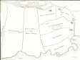
| Description |
A B&W photo copy of a portion of a Marblehead map in the year 1700. The map shows the harbor from Waldron's Cove and the present Skinner's Head, SW for 3000 feet along the harbor. Land parcels are shown, along with the owners' names. |
| Home Location |
FP Box 18X13 Alfa Shelf#1 |
| Object ID |
1961-002-03658 |
| Object Name |
Print, Photographic |
| Search Terms |
Marblehead Map segment |
| Sub-category |
Documentary Artifact |
| Subjects |
Maps |
| Title |
Marblehead Map segment |
|
|
COPYRIGHT INFORMATION ~ This image is the property of the Marblehead Historical Commission and may not be used in any form without prior permission. When using this image with permission, the credit information should be in the following format: Image courtesy of the Marblehead Historical Commission, Marblehead, MA.
|
|
|
Rev. 1.0a 1/2009 Contact the Historical Commission at 781-639-3425 or e-mail us (please include the "Object ID" number) at: butlerw@marblehead.org
Last modified on: January 05, 2009
|