|
Record 1281/1387 |
|
Description
|
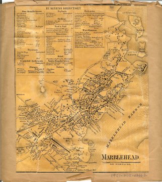
| A B&W map of Marblehead downtown area and the waterfront, including a Business Directory. Most of the streets are named, and buildings are shown as small squares on the map. A number of the building owners are identified. Along the waterfront, coves and wharfs are identified. See 1961-002-03661. The front page of the backing paper is labelled "1856, Marblehead Mass, From map of Essex County, Henry F. Walling". The front also has a stamp of "Charles D. Craigie P.O. Box 1203, Boston 1, Mass. Property Atlases and Maps". |
Marblehead Map segment
-Topic: Around town
-This image is the property of the Marblehead Historical Commission
COPYRIGHT INFORMATION ~ This image is the property of the Marblehead Historical Commission and may not be used in any form without prior permission. When using this image with permission, the credit information should be in the following format: Image courtesy of the Marblehead Historical Commission, Marblehead, MA.
| Marblehead Map segment |
COPYRIGHT INFORMATION ~ This image is the property of the Marblehead Historical Commission and may not be used in any form without prior permission. When using this image with permission, the credit information should be in the following format: Image courtesy of the Marblehead Historical Commission, Marblehead, MA.