Town of Marblehead Proposed Road from Norman St. to Lafayette St, February 1931
Archives Catalog
|
|
|
| Collection |
Marblehead Town History |
| Date |
February 1931 |
| Abstract |
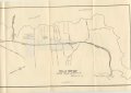
A map of the West shore of Marblehead and Salem Harbor showing the proposes road which became West Shore Drive. It starts at the corner of Norman Street and Gingerbread Hill, follows Beacon Street to Green Street and then directly to the corner of Lafayette Street and Maple Street. It was drawn by Town Engineer, H.B. Breare, dated February 1931. |
| Home Location |
S Document Box Delta Shelf#3 |
| Object ID |
1994-004-008 |
| Object Name |
Map |
| People |
Breare, H. B. |
| Search Terms |
West Shore Drive |
| Title |
Town of Marblehead Proposed Road from Norman St. to Lafayette St, February 1931 |
|
|
COPYRIGHT INFORMATION ~ Contact the Marblehead Historical Commission for rights to use this image.
|
|
|
Rev. 2.0 2/2013 Contact the Historical Commission at 781-639-3425 or e-mail us (please include the "Object ID" number, not the Record Number)
historic@marblehead.org
Last modified on: February 22, 2013
|