|
Record 365/5355 |
|
|
|
Description
|
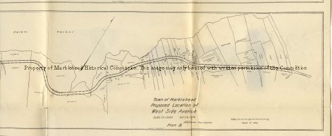
| A map of the West shore of Marblehead and Salem Harbor showing the proposed road which became West Shore Drive. This sheet contains 3 different proposals. 1) Drawn by Ernest W. Bowditch Engineer, Boston on February 1903 follows close along the shore of Salem Harbor. Noted as plan A 2) Drawn by H.B. Beare, Town Engineer on Oct. 29, 1924 is further from the shore line but still is much closer to Salem Harbor than the finished West Shore Drive. Noted as plan B 3) Drawn by H.B. Breare, Town Engineer on Jan. 10, 1925 is still further inland and much straighter than previous proposals. Noted as plan C |
Proposed Location of West Side Avenue
-Archives Catalog
-Copyright Marblehead Historical Commission
COPYRIGHT INFORMATION ~ Contact the Marblehead Historical Commission for rights to use this image.
| Plan B West side Avenue |
COPYRIGHT INFORMATION ~ Contact the Marblehead Historical Commission for rights to use this image.