| Collection |
Marblehead Buildings |
| Date |
1882 |
| Abstract |
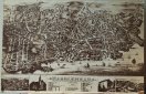
Map/drawing of Marblehead as far as Sewell, Elm & Pond streets to the North and Chestnut and Village streets to the West and the harbor to the South. The buildings are drawn in together with rail road tracks and a train and boats in the harbor. The major buildings and places numbered and listed at the bottom. Also at the bottom are 4 additional drawings, Devereux map, Abbot Hall, Marblehead Academy, and Peaches Point map. Printed in brown ink. |
| Home Location |
EN Corrugated Folder Wood Shelf Top |
| Object ID |
2001-065-0192 |
| Object Name |
Map |
| People |
Graves, M.H.
Bailey, G.H. |
| Search Terms |
Marblehead Maps |
| Title |
Marblehead |
|