|
Record 547/5355 |
|
Description
|
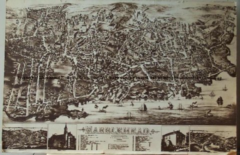
| Map/drawing of Marblehead as far as Sewell, Elm & Pond streets to the North and Chestnut and Village streets to the West and the harbor to the South. The buildings are drawn in together with rail road tracks and a train and boats in the harbor. The major buildings and places numbered and listed at the bottom. Also at the bottom are 4 additional drawings, Devereux map, Abbot Hall, Marblehead Academy, and Peaches Point map. Printed in brown ink. |
Marblehead
-Archives Catalog
-Copyright Marblehead Historical Commission
COPYRIGHT INFORMATION ~ Contact the Marblehead Historical Commission for rights to use this image.
| Marblehead Map/Drawing |
COPYRIGHT INFORMATION ~ Contact the Marblehead Historical Commission for rights to use this image.