Boston From 1630
Archives Catalog
|
|
|
|
| Collection |
General Collection |
| Date |
c. 1970 |
| Abstract |
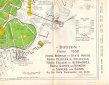
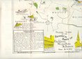
A sheet with maps on both sides.
On one side is a map of Boston MA as it was in 1630 soon after it was settled. It is colored green. The present (1970) boundaries are outlined but not colored. Included are several drawings of various historic buildings and scenes with descriptions and dates.
The other side is a map of the area from Boston to Concord showing and describing the rides of Revere, Dawes, and Pescott to warn the Minute men in the surrounding towns of the coming of the British. This map is also illustrated with drawings and dates. |
| Home Location |
N Box 18X13 Charlie Shelf#4 |
| Object ID |
2004-004-017 |
| Object Name |
Map |
| People |
Revere, Paul
Dawes, William
Prescott, Dr. |
| Search Terms |
American Revolution |
| Title |
Boston From 1630 |
|
|
COPYRIGHT INFORMATION ~ Contact the Marblehead Historical Commission for rights to use this image.
|
|
|
Rev. 2.0 2/2013 Contact the Historical Commission at 781-639-3425 or e-mail us (please include the "Object ID" number, not the Record Number)
historic@marblehead.org
Last modified on: February 22, 2013
|