|
Record 2667/5355 |
|
|
|
Description
|
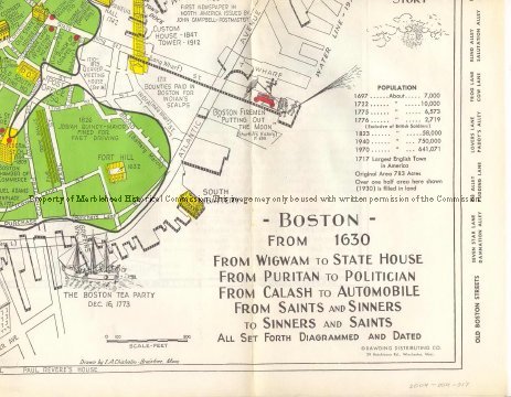
| A sheet with maps on both sides. On one side is a map of Boston MA as it was in 1630 soon after it was settled. It is colored green. The present (1970) boundaries are outlined but not colored. Included are several drawings of various historic buildings and scenes with descriptions and dates. The other side is a map of the area from Boston to Concord showing and describing the rides of Revere, Dawes, and Pescott to warn the Minute men in the surrounding towns of the coming of the British. This map is also illustrated with drawings and dates. |
Boston From 1630
-Archives Catalog
-Copyright Marblehead Historical Commission
COPYRIGHT INFORMATION ~ Contact the Marblehead Historical Commission for rights to use this image.
| Boston 1630 |
COPYRIGHT INFORMATION ~ Contact the Marblehead Historical Commission for rights to use this image.