|
Record 2901/5355 |
|
|
|
Description
|
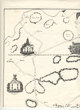
| A map of Marblehead which includes the Harbor, part of the Neck, all of Peach's Point and Naugus Head and as far to the West as the Hill where the old High School (now Middle School) was. The buildings are drawn a the owner's noted. there are also drawings of several Semi-public buildings (Clockwise starting in the harbor): 1. Unitarian Meeting House 2. Baptist Meeting House 3. Marblehead Bank 4. Grand Bank 5. Orthodox Meeting House 6. Methodist Meeting House St. Michael's Church is not drawn and the Orthodox Meeting House looks like the Old North Church on Washington Street. |
Plan of Marblehead Mass. from Actual Survey by H. McIntyre Cl. Engr. 1850
-Archives Catalog
-Copyright Marblehead Historical Commission
COPYRIGHT INFORMATION ~ Contact the Marblehead Historical Commission for rights to use this image.
| Top Left Quarter |
COPYRIGHT INFORMATION ~ Contact the Marblehead Historical Commission for rights to use this image.