|
|
| Collection |
General Collection |
| Date |
December 8, 1961 |
| Abstract |
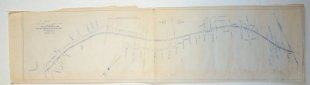
This map shows the land taken from the Boston and Maine Railroad for Sewerage purposes. it extends from Maverick Street all the way to the end of town line near Swampscott. |
| Home Location |
GG Pink Room Flat File Drawer#2 |
| Object ID |
2007-201-02140 |
| Object Name |
Map |
| Search Terms |
Marblehead maps |
|
|
COPYRIGHT INFORMATION ~ Contact the Marblehead Historical Commission for rights to use this image.
|
|
|
Rev. 2.0 2/2013 Contact the Historical Commission at 781-639-3425 or e-mail us (please include the "Object ID" number, not the Record Number)
historic@marblehead.org
Last modified on: February 22, 2013
|