Topic: Around town
Atlas of Massachusetts
|
|
|
|
| Catalog date |
01/27/2003 |
| Category |
8: Communication Artifact |
| Classification |
Towns
Cities
Geography
Maps |
| Collection |
Marblehead Town History |
| Date |
1891-1892 |
| Abstract |
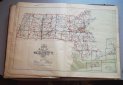
An Atlas of Massachusetts consisting of:
56 Maps of which each covers two pages with the backs blank
27 of the 56 are "Atlas Plates" numbered one through twenty-seven
1 is a map of Massachusetts showing which part of the state is covered by the "Atlas Plates"
28 are street maps of some of the cities of the state, none are maps of towns.
All the maps are bound in a book with and index of various location in the state (not cities or towns) such as post offices, ponds, hills, islands and other geographical features. It has a preface which list many of the local civil engineers and surveyors who assisted in compiling the information. |
| Home Location |
AE Metal Edge Newspaper Box Delta Shelf Top |
| Object ID |
1973-001-044 |
| Object Name |
Map |
| Search Terms |
Marblehead History |
| Sub-category |
Documentary Artifact |
| Subjects |
Maps |
| Title |
Atlas of Massachusetts |
| Year Range from |
1891 |
| Year range to |
1892 |
|
|
COPYRIGHT INFORMATION ~ This image is the property of the Marblehead Historical Commission and may not be used in any form without prior permission. When using this image with permission, the credit information should be in the following format: Image courtesy of the Marblehead Historical Commission, Marblehead, MA.
|
|
|
Rev. 1.0a 1/2009 Contact the Historical Commission at 781-639-3425 or e-mail us (please include the "Object ID" number) at: butlerw@marblehead.org
Last modified on: January 05, 2009
|