Topic: Around town
Atlas of Marblehead, Massachusetts
|
|
|
|
| Catalog date |
01/27/2003 |
| Category |
8: Communication Artifact |
| Classification |
Towns
Geography
Maps |
| Collection |
Marblehead Town History |
| Date |
1881 |
| Abstract |
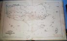
An atlas of street maps of Marblehead consisting of 14 double page plates. One plate covers the whole of the town and 13 are enlarged section of the town. Each plate is labeled with a letter from A through N.
Plate "C" is missing which contains the area bounded by Washington Street at Pearl Street to Pleasant Street, Pleasant Street to Spring Street, Spring Street to what is now Evans Road, along Evans Road to approximately Shepard Street then to what is now the corner of Farrell Lane and Pond Street, across vacant land to the corner of Back Street (now Elm Street) and Pearl and down Pearl to the point of origin. |
| Home Location |
AE Metal Edge Newspaper Box Delta Shelf Top |
| Object ID |
1973-001-045 |
| Object Name |
Map |
| Search Terms |
Marblehead History |
| Sub-category |
Documentary Artifact |
| Subjects |
Maps |
| Title |
Atlas of Marblehead, Massachusetts |
| Year Range from |
1881 |
|
|
COPYRIGHT INFORMATION ~ This image is the property of the Marblehead Historical Commission and may not be used in any form without prior permission. When using this image with permission, the credit information should be in the following format: Image courtesy of the Marblehead Historical Commission, Marblehead, MA.
|
|
|
Rev. 1.0a 1/2009 Contact the Historical Commission at 781-639-3425 or e-mail us (please include the "Object ID" number) at: butlerw@marblehead.org
Last modified on: January 05, 2009
|