Topic: Around town
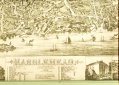
Marblehead
|
|
|
|
| Catalog date |
02/24/2003 |
| Category |
8: Communication Artifact |
| Classification |
Maps |
| Collection |
General Collection |
| Date |
1882 |
| Abstract |
Map/drawing of Marblehead as far as Sewell, Elm & Pond streets to the North and Waldron and School streets to the West and the harbor to the South. The buildings are drawn in together with rail road tracks and boats in the harbor. The major buildings and places numbered and listed at the bottom. Also at the bottom are 4 additional drawings, Devereux map, Abbot Hall, Marblehead Academy, and Peaches Point map. Printed in brown ink.
It is the same as #2001-065-0192 except it has been cut to fit in the frame. |
| Home Location |
Hanging on wall |
| Object ID |
2000-008-008 |
| Object Name |
Map |
| People |
Graves, M. H
Bailey, G. H. |
| Search Terms |
Marblehead Maps |
| Sub-category |
Documentary Artifact |
| Subjects |
Maps
Buildings
Drawing |
| Title |
Marblehead |
| Year Range from |
1882 |
|
|
COPYRIGHT INFORMATION ~ This image is the property of the Marblehead Historical Commission and may not be used in any form without prior permission. When using this image with permission, the credit information should be in the following format: Image courtesy of the Marblehead Historical Commission, Marblehead, MA.
|
|
|
Rev. 1.0a 1/2009 Contact the Historical Commission at 781-639-3425 or e-mail us (please include the "Object ID" number) at: butlerw@marblehead.org
Last modified on: January 05, 2009
|