Topic: Around town
Atlas of Marblehead, Massachusetts
|
|
|
|
| Catalog date |
01/27/2003 |
| Category |
8: Communication Artifact |
| Classification |
Towns
Geography
Maps |
| Collection |
Marblehead Town History |
| Date |
1893-1912 |
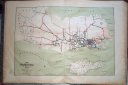
| Abstract |
An atlas of street maps of Marblehead consisting of 15 double page maps, one map of the whole town and 14 street maps of various parts of the town. Each lot is identified with the name of the owner and its square footage. The type of construction and uses are also indicated. |
| Home Location |
AE Metal Edge Newspaper Box Delta Shelf Top |
| Object ID |
1973-001-046 |
| Object Name |
Map |
| Search Terms |
Marblehead History |
| Sub-category |
Documentary Artifact |
| Subjects |
Maps |
| Title |
Atlas of Marblehead, Massachusetts |
| Year Range from |
1893 |
| Year range to |
1912 |
|
|
COPYRIGHT INFORMATION ~ This image is the property of the Marblehead Historical Commission and may not be used in any form without prior permission. When using this image with permission, the credit information should be in the following format: Image courtesy of the Marblehead Historical Commission, Marblehead, MA.
|
|
|
Rev. 1.0a 1/2009 Contact the Historical Commission at 781-639-3425 or e-mail us (please include the "Object ID" number) at: butlerw@marblehead.org
Last modified on: January 05, 2009
|