|
Record 628/1387 |
|
|
|
Description
|
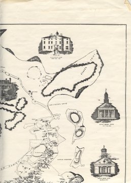
| A map of Marblehead which includes the Harbor, part of the Neck, all of Peach's Point and Naugus Head and as far to the West as the Hill where the old High School (now Middle School) was. The buildings are drawn a the owner's noted. there are also drawings of several Semi-public buildings (Clockwise starting in the harbor): 1. Unitarian Meeting House 2. Baptist Meeting House 3. Marblehead Bank 4. Grand Bank 5. Orthodox Meeting House 6. Methodist Meeting House St. Michael's Church is not drawn and the Orthodox Meeting House looks like the Old North Church on Washington Street. |
Plan of Marblehead Mass. from Actual Survey by H. McIntyre Cl. Engr. 1850
-Topic: Around town
-This image is the property of the Marblehead Historical Commission
COPYRIGHT INFORMATION ~ This image is the property of the Marblehead Historical Commission and may not be used in any form without prior permission. When using this image with permission, the credit information should be in the following format: Image courtesy of the Marblehead Historical Commission, Marblehead, MA.
| Top Right Quarter |
COPYRIGHT INFORMATION ~ This image is the property of the Marblehead Historical Commission and may not be used in any form without prior permission. When using this image with permission, the credit information should be in the following format: Image courtesy of the Marblehead Historical Commission, Marblehead, MA.