Topic: Around town
(none)
|
|
|
| Catalog date |
10/27/2005 |
| Category |
8: Communication Artifact |
| Classification |
Maps |
| Collection |
William Hammond Collection |
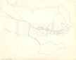
| Abstract |
A hand drawn map of Marblehead showing the old roads leading to the town. It shows the Old Salem Road that crosses Forrest river at Legg's Hill, the two roads that are now Humphrey and Tedesco Streets, the road SE of the marsh behind Devereux Beach that leads to the causeway, the Green Street and Beacon Street "Ways to the Ferry" and Front, Washington and the streets between them. |
| Home Location |
Z Box 18X13 Charlie Shelf#4 |
| Object ID |
2005-018-00143 |
| Object Name |
Map |
| Search Terms |
Marblehead Maps |
| Sub-category |
Documentary Artifact |
| Subjects |
Maps |
| Title |
(none) |
|
|
COPYRIGHT INFORMATION ~ This image is the property of the Marblehead Historical Commission and may not be used in any form without prior permission. When using this image with permission, the credit information should be in the following format: Image courtesy of the Marblehead Historical Commission, Marblehead, MA.
|
|
|
Rev. 1.0a 1/2009 Contact the Historical Commission at 781-639-3425 or e-mail us (please include the "Object ID" number) at: butlerw@marblehead.org
Last modified on: January 05, 2009
|