Topic: Around town
Marblehead 1872
|
|
|
| Catalog date |
07/10/2008 |
| Category |
8: Communication Artifact |
| Classification |
Maps
Marblehead Harbor
Marblehead Neck
Marblehead Places |
| Collection |
Marblehead Maritime Museum, Sponsored by Dr. Raymond F. Cole, Jr. |
| Date |
1872 |
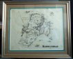
| Abstract |
Framed under glass map of Marblehead dated 1872.
This map features the following:
1. The names of owners of houses not in the main residential area from the Shipyards to Fort Sewall
2. The Marblehead Branch R.R. but not the railroad from Swampscott.
3. Atlantic Avenue from The Swampscott line to Ocean avenue.
4. Four Indian cemetery
A. opposite Great Head (Now known as Castle Rock)
B. Just south of Waterside Cemetery
C. At Wyman's Cove.
D. About where Treat Road is now.
5. Most of the Neck is labeled Camp Lowell Village. The area north of Castle Rock is labeled Nashua Village.
6. There is a Ice Ho (ice house) on West Street.
7. Children's Island is labeled Lowell or Cat Is. |
| Home Location |
Cabinet Bravo Top Shelf |
| Object ID |
2007-300-03312 |
| Object Name |
Map |
| Search Terms |
Marblehead Map 1872 |
| Sub-category |
Documentary Artifact |
| Subjects |
Maps
Cemeteries
Causeways |
| Title |
Marblehead 1872 |
|
|
COPYRIGHT INFORMATION ~ This image is the property of the Marblehead Historical Commission and may not be used in any form without prior permission. When using this image with permission, the credit information should be in the following format: Image courtesy of the Marblehead Historical Commission, Marblehead, MA.
|
|
|
Rev. 1.0a 1/2009 Contact the Historical Commission at 781-639-3425 or e-mail us (please include the "Object ID" number) at: butlerw@marblehead.org
Last modified on: January 05, 2009
|