Topic: Around town
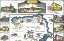
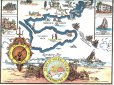
C. H. Snow Marblehead Map
|
|
|
|
| Catalog date |
05/07/2008 |
| Category |
8: Communication Artifact |
| Classification |
Maps
Marblehead Places
Marblehead History |
| Collection |
General Collection |
| Date |
1929 |
| Abstract |
Print of a hand-colored map of Marblehead originally made by C. H. Snow in 1929 and colored by Warren Perry in 2008. The map shows the outlines of Marblehead peninsula and the Neck, along with historical pieces of information. The map is surrounded by drawings of historical Marblehead buildings and the Hannah. |
| Home Location |
Drawers in Cabinet in Conference Room |
| Object ID |
2008-027-00098 |
| Object Name |
Map |
| People |
Snow, C. H.
Perry, Warren |
| Search Terms |
Marblehead Map |
| Sub-category |
Documentary Artifact |
| Subjects |
Maps
Marblehead Neck
Marblehead Harbor
Historic buildings
Historic sites
Historical Ships |
| Title |
C. H. Snow Marblehead Map |
|
|
COPYRIGHT INFORMATION ~ This image is the property of the Marblehead Historical Commission and may not be used in any form without prior permission. When using this image with permission, the credit information should be in the following format: Image courtesy of the Marblehead Historical Commission, Marblehead, MA.
|
|
|
Rev. 1.0a 1/2009 Contact the Historical Commission at 781-639-3425 or e-mail us (please include the "Object ID" number) at: butlerw@marblehead.org
Last modified on: January 05, 2009
|