|
|
| Collection |
William Hammond Collection |
| Abstract |
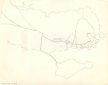
A hand drawn map of Marblehead showing the old roads leading to the town. It shows the Old Salem Road that crosses Forrest river at Legg's Hill, the two roads that are now Humphrey and Tedesco Streets, the road SE of the marsh behind Devereux Beach that leads to the causeway, the Green Street and Beacon Street "Ways to the Ferry" and Front, Washington and the streets between them. |
| Home Location |
Z Box 18X13 Charlie Shelf#4 |
| Object ID |
2005-018-00143 |
| Object Name |
Map |
| Search Terms |
Marblehead Maps |
| Title |
(none) |
|
|
COPYRIGHT INFORMATION ~ Contact the Marblehead Historical Commission for rights to use this image.
|
|
|
Rev. 2.0 2/2013 Contact the Historical Commission at 781-639-3425 or e-mail us (please include the "Object ID" number, not the Record Number)
historic@marblehead.org
Last modified on: February 22, 2013
|