|
Record 1280/1387 |
|
|
|
Description
|
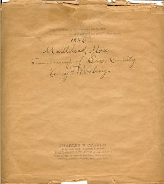
| A colored map of Marblehead cut out from a larger map and pasted onto backing paper. The map includes mainland Marblehead, the harbor, the Neck and several islands and rocks. It includes a number of streets and the "Marblehead Branch Railroad" - scale is too small to show street names. The front page of the backing paper is labelled "1856, Marblehead Mass, From map of Essex County, Henry F. Walling". The front also has a stamp of "Charles D. Craigie P.O. Box 1203, Boston 1, Mass. Property Atlases and Maps". |
Marblehead Map segment
-Topic: Around town
-This image is the property of the Marblehead Historical Commission
COPYRIGHT INFORMATION ~ This image is the property of the Marblehead Historical Commission and may not be used in any form without prior permission. When using this image with permission, the credit information should be in the following format: Image courtesy of the Marblehead Historical Commission, Marblehead, MA.
| Marblehead Map |
COPYRIGHT INFORMATION ~ This image is the property of the Marblehead Historical Commission and may not be used in any form without prior permission. When using this image with permission, the credit information should be in the following format: Image courtesy of the Marblehead Historical Commission, Marblehead, MA.